This
is the first of three reports on our 200 mile Coast to Coast walk across England, covering the 63-mile segment from
St. Bees to the village of Shap.


 |
| Map sourced from www.contours.co.uk |
The
Coast to Coast Path traverses northern England for over 190 miles starting in
St. Bees at the Irish Sea and finishing at Robin Hood’s Bay at the North Sea.
Our plan is to walk this distance over eighteen days with a handful of rest
days here and there. With side trips to pubs for sustenance and some
backtracking due to the high likelihood of getting lost, we anticipate we will be
walking over 200 miles. That’s if our bodies hold up.
Our
first test wasn’t a physical one. Instead, it was one of patience and stress
management due to our travails of getting to this part of England in the first
place. After enduring the aggravation of flight delays and cancellations out of
O’Hare (go figure), we were re-routed through Munich, Germany then, eventually,
to an overnight stop in Manchester, England. To add to our discomfort, there
was no hot water in our downtown hotel for what was a much-anticipated shower. Clean,
but chilled, the next morning had us on two separate trains that eventually delivered
us to the small village of St. Bees, forty-eight hours after we left home, where
we wearily checked into our rustic, yet comfortable hotel. And this one had hot
water.
After
relaxing a bit, Mary Kay soon found a nice quite corner in our hotel’s pub to
read and sip her soothing cup of decaf. I, on the other hand, spent the better
part of the evening on a bar stool sipping my soothing glass(es) of beer while talking
with the bartender and a couple of customers about the finer points of Brexit,
the politics of our respective countries, tourism’s and the nearby nuclear
power plant’s economic impact on the region and, of all things, Antarctic
expeditions (it’s a long story).
St. Bees to Cleator
Following
tradition, we each picked up a pebble at this Irish Sea beach and plan on carrying
it with us across the width of England where we are to throw it into the North
Sea upon completion of our trek. Tradition also had us get the heels of our
boots wet at this beach. To properly bookend this trek, we will then get the
toes of our boots wet after reaching the beach at Robin Hood’s Bay some 200
miles and three weeks from now.


The strong
winds buffeted us as we climbed from the beach to the headlands above. Long stretches
of the trail hugged the cliff-sides not far from the drop-offs to the rocks far
below. We were thankful the winds blew us away from these precipitous edges
rather than toward them.


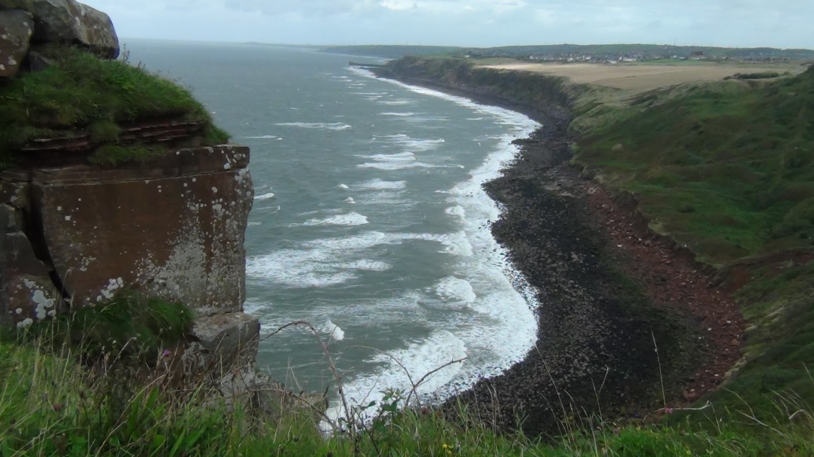
Out at
sea, banks of low hanging clouds with hanging veils of rain marched their way
toward shore. For most of the morning, we were able to dodge these rains,
either quickening our pace to out-run them or slowing down to let them pass far
ahead of us. By the afternoon, after the trail turned and we headed inland, we
weren’t so lucky and found ourselves drenched on more than one occasion.


While
our trail guidebook and map sheets were critical in helping us navigate the twists
and turns of our route, there were some gaps in route-finding instructions. One of the roads
we walked down dead-ended to a gated-off lane where a farmer and his family were
leading their cows to the nearby barns. It was unclear from the books and maps
as to which way we were to turn.
 |
| The guidebook and maps we are using to navigate. |
While puzzling
over these books and maps, the farmer called out to us, opened the gates, and
walked with us while showing us the way through his maze of barns, sheds, and
the building that made up his and his family’s home while assuring us that we
were indeed following the correct course. I think if this was to occur in the U.S.,
we would have not been met with such friendliness, but instead would have been
greeted with the business end of a shotgun and a shout for us to “get off my
g*#@*#d land!”
By
design, this first day’s walk was a relatively short one, nine to ten miles or
so, so as to get used to the rigors of our days ahead when greater mileage will
be called for. Despite this so-called short day, we were weary near its
conclusion and had to stop for a break in the village of Moor Row, only a mile and
a half short of our hotel in Cleator, where we found refreshment in the form of
coffee and sweetcakes at a small store tucked in between a row of otherwise
non-descript houses.

Cleator
to Gillerthwiate
The
sun shone brightly on this glorious day. Temperatures were in the mid-fifties.
For us, this was perfect hiking weather as we entered the Lake District, an
area renowned for its treeless mountains, deep water lakes, and overall beauty.

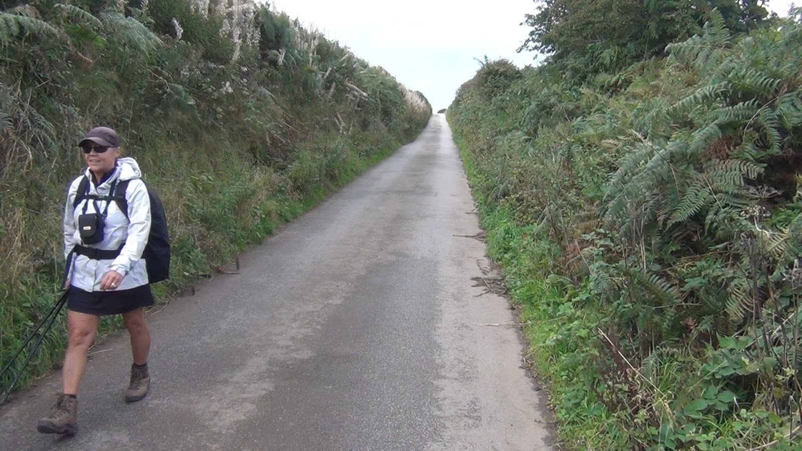
Soon
after our start, signs warned us not to proceed past a gray steel gate that
blocked our way. Forestry operations were underway up the designated route and
the loggers didn’t want any hikers out and about in their work area. A
well-signed detour took us down small country lanes, the pavement of which was
only one car in width, and added about an extra mile to our planned 11 mile
day. The good thing, though, is that this detour took us around what would
otherwise have been a steep climb up and over Dent Hill.
The
other bonus was that these lanes were bordered by hedgerows overgrown with
bushes full of ripe, fat, and juicy blackberries. What would go for $2.99 a
pint back home was here free for the taking, and in unlimited quantities at
that. We paused frequently to pick the fruit, taste their deliciousness, and
slowly watch our fingertips turn purple from the effort.

When
the pavement finally ended, a muddy and rocky trail took over. After years of
boots and bikes, erosion caused it to become its own stream. The rising sun
glinted off of the running water creating a glare that made it difficult to
discern one path from another. This resulted in us getting turned around a bit
when we took a wrong track where the trail braided into numerous branches.
Fortunately, we discovered our error after only a few hundred feet. We cut
across a soggy, sheep-filled meadow to connect back to the correct route, but
not after getting our boots soaked.

After
refreshing ourselves with sandwiches and snacks at a shop in Ennerdale Bridge,
we turned to follow a shoreline path down the southern side of the Ennerdale Lake.
This gem was spectacularly situated amongst hills and mountains located at its
flanks. However, this was no casual stroll. When we finally reached the end of
the lake, our feet and ankles were sore from having to walk on and over an
infinite number of rocks, roots, and boulders all having an infinite number of
sizes and shapes designed to easily make one trip, slip, or fall.


We
reached our remote hostel by mid-afternoon. Tired and trail-weary, we quickly
agreed to take the receptionist up on her offer to upgrade into a private room.
We just weren’t in the mood to share our sleeping quarters with other hikers
after our long day of trail walking.
Though
tired, we were feeling good about the mileage we have covered so far on our
first two days. However, any notion that this was something noteworthy was
quickly dispelled at dinner. Seated nearby our table was Phillip, a
fifty-something year old man from Brighton who was walking solo. We learned
from him that he just finished in one day the twenty-plus miles it has taken us
two full days to cover.
Gillerthwaite
to Longthwaite
We are
big believers in the karma gained when we “pay it forward”, the practice where instead of paying back a person who has just helped you out with something, you instead commit to doing something nice for someone else at sometime in the near future. And we do just that
anytime we are presented with an opportunity to do so. This morning was an
example.
Our
hostel’s manager, upon learning we would be staying at another hostel later
tonight, asked if we could deliver a package for her. It seems someone had left
behind a small wallet containing a driver’s license, a couple of credit cards,
and a fistful of cash. Given our remote location, the only expeditious way to
deliver this was by us, or someone, walking it out to the next village in the
valley up and over the mountains.
She
made some calls and was assured that if we took the wallet to the next hostel,
it would then be delivered by a courier via a mountain road to the
more-than-likely frantic owner who, at this point, was a day or so ahead of us.
We happily obliged knowing it was not only the right thing to do, but that it
would add to our growing stock of karma credits.
Mid-morning, we stopped at an intervening hostel to have a cuppa and chat with the resident manager. We learned this was one of the most remote hostels in all of England. Joining us was Phillip, the long-distance walker from Brighton we had met last night. He took off before we could finish our coffee. I had to call out after him when it became apparent he was heading down the wrong trail. I only knew this because this confusing spot was clearly warned about in my guidebook. The hostel’s manager thanked me for helping the man out saying that he has to do so likewise for many others during the course of a day. He said most have the same guidebook we have, but that they don’t bother to read it.
Mid-morning, we stopped at an intervening hostel to have a cuppa and chat with the resident manager. We learned this was one of the most remote hostels in all of England. Joining us was Phillip, the long-distance walker from Brighton we had met last night. He took off before we could finish our coffee. I had to call out after him when it became apparent he was heading down the wrong trail. I only knew this because this confusing spot was clearly warned about in my guidebook. The hostel’s manager thanked me for helping the man out saying that he has to do so likewise for many others during the course of a day. He said most have the same guidebook we have, but that they don’t bother to read it.
 |
| MK and the hostel manager go over directions and advice. |

The
steep climb from here took us up about 1000 feet over the course of one and a
half miles. At the pass, we enjoyed the lack of any winds and the views of the
far-off lakes below us that weren’t yet obscured since the clouds overhead
hadn’t yet descended to our level.


Many
day-hikers were coming up the trail as we descended down into the next valley.
Near the base, a slate mine was in operation. Nearby was a museum, and attached
cafe, that extolled the benefits and uses of all things slate.

Down
into the valley proper, we found our hostel nestled in a grove of trees and
adjacent to a clear running mountain fed stream. Before doing anything else, we
happily handed over the wallet to the manager who would see to it that it would
be advanced to the rightful owner.

 |
| Our hostel in Longthwaite in the Borrowdale Valley. |
Longthwaite
to Grasmere
We
said goodbye to Phillip at the breakfast table. He was about to set off for
another marathon day, this time walking 17 miles to the village of Patterdale,
which was our destination two days from now.
 |
| Phillip, from Brighton, England. |
The
morning clouds, full of rain and mist, hung low, obscuring the ridge tops high
above where we would be walking later in the day. We started out, though,
traversing through the Borrowdale valley in overcast but relatively rain-free
skies following the Stonethwaite river up slope to its eventual source high
above us.


 |
| Sheep graze along the trail everywhere we have been. |

The river
formed numerous waterfalls the higher we ascended. The overnight rains at these
higher elevations helped create and add to these torrents. The trail too was full
of water. Boggy, boot-sucking mud and mire made for very slow going.


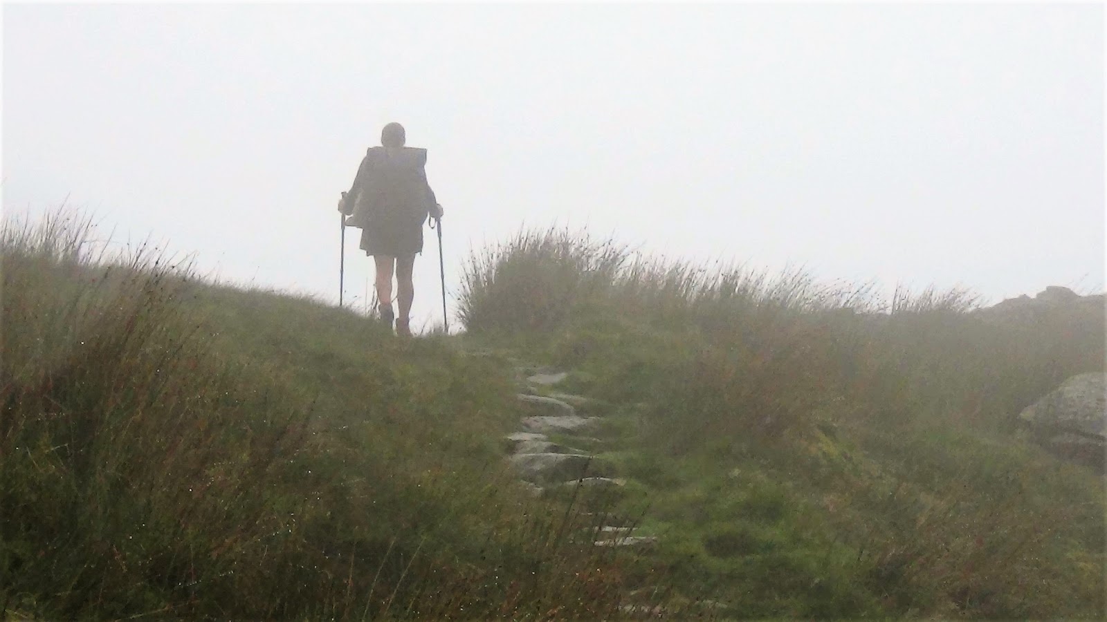
The cloud
ceiling had lowered and had obscured any views as we reached the pass. In fact,
seeing anything beyond 25 yards was very difficult. Navigation was almost impossible. Get turned around up here, and you'd be lost until things cleared up days from now. We split up, yet kept each other in sight, so as to increase our odds of
finding the handful of rock cairns that marked the direction of the trail and which
were critical for our wayfinding.
At one point, I could see the white coat of a grazing sheep off in the murkiness. I watched as it started to move on. My gaze looked past this ghost sheep in the direction it was walking as it began to disappear in the fog. It was only then that I was able to discern the next cairn, the next critical marker in our course over this pass that I would likely not have seen had it not been for this mysterious animal.
At one point, I could see the white coat of a grazing sheep off in the murkiness. I watched as it started to move on. My gaze looked past this ghost sheep in the direction it was walking as it began to disappear in the fog. It was only then that I was able to discern the next cairn, the next critical marker in our course over this pass that I would likely not have seen had it not been for this mysterious animal.
 |
| MK points the way to the next rock cairn. |
 |
| Found one! These cairns were critical markers showing the way over the foggy pass. |
After
a lot of hunting and searching, we found our way over the pass and down into
the valley toward Grasmere. While our pace was pathetically slow, others were
yet even slower. We passed groups of hikers as we descended. One couple, from Toledo,
shared with us their story of getting lost up at the pass. In fact, at one point,
they got so turned around, they went in a completely wrong direction back down to
the valley they had started out from. If not for another hiker’s GPS unit, who
had fortunately come by at a pivotal moment, this couple would likely still be
wandering around up on these mountaintops.

These
walks in these conditions is not like what you would experience on the paths
back home in your local park where you can average three to four miles an hour.
Here, because of the rocks, roots, bogs and streams, we are finding our pace to average out at a little over one and sometimes
as high as two miles an hour. Our eight to ten-mile day today took us a little over six
hours to complete. We were tired. We were hungry. All we wanted to do when we
staggered into our hostel was to eat.


And
eat we did, over the course of one evening and all of the following day, for we
chose the village of Grasmere for a so-called “zero” day, a day off without gaining any
mileage down the trail. In fact, we probably consumed enough food and calories
to more than make up for all that we lost during our past four days of hikes.
This
was also the last of our stays in hostels. From here out, inns and B&Bs
would serve as our overnight lodgings.
 |
| The hostels we have stayed at have been very nice, almost luxurious. |
 |
| Although, its apparent their plumbing might need to be upgraded. |
We
could barely hear the receptionist when we checked in for she was very
soft-spoken.
“We lock the doors early. If you come back late, perhaps because you’ve spent too long at the pub, use the key fob and the sensor will open the doors,” she said, barely above the sound of a whisper.
“We lock the doors early. If you come back late, perhaps because you’ve spent too long at the pub, use the key fob and the sensor will open the doors,” she said, barely above the sound of a whisper.
“Well,
we’re not the pub-going type,” we said, with normal sounding voices. “We’ll be
back in plenty of time.”
“Oh.
Then maybe you’ll be out stargazing or something.” She said this with somewhat
of a wink and a sparkle in her eye as if to say it’s okay with her if we might
choose to be out and about doing something naughty late into the evening.
The
next day, we joined the hundreds of tourists who descended on the town and
milled about on the small streets and narrow lanes. Grasmere was once home to
the poet William Wordsworth and many had made the pilgrimage here to see where
he worked and lived.
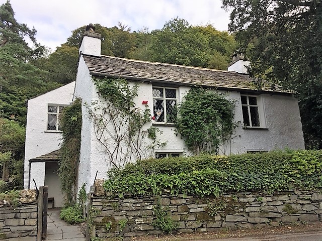 |
| Dove Cottage, where Wordsworth did his work. |
 |
| Quaint Grasmere. |
I’m
not a student of poetry and know nothing of the man’s work, other than the
quote he had about Grasmere that we saw on a variety of signs on street corners
and in the shops:
“The loveliest spot that man hath ever known”
“The loveliest spot that man hath ever known”
I guess that if one uses the word "hath" instead of "has", it is considered high brow poetry.
Instead
of investigating his poetry further, we spent the better part of the day
walking in and out of shops, bakeries, and gift stores doing the tourist thing.
In time, I was getting sleepy and was in the mood for a nap.


 |
| I'm generally not a big fan of gift stores, but some of them I actually liked. |
I can
be overbearing at times and a bit too intense, so I made a suggestion. “I think
I’m going to go back to the hostel for a short snooze,” I said to MK. “Maybe
you’d want to do your own thing and take advantage of a chance for some alone
time?”
“OK!”
She responded, “I’ll do that. See you back at the hostel in an hour or so.” And
off she went.
Was it
just my imagination or was she too quick to agree to this?


Grasmere
to Patterdale
A cold
front passed through overnight and brought with it some rain, temperatures in
the 40s, and a strong, gusty wind. The skies cleared just as we got underway
but the cold winds continued to howl. Fortunately, the wind was blowing from behind
us and served to propel us somewhat up the Tongue Gill valley toward Grisedale
Tarn at the pass and then down into the Patterdale valley.


The
views as we reached the top were spectacular. We stopped from time to time to
soak in the beauty for to linger too long meant getting chilled to the bone.
There were times when the winds, using the profile of our bodies with our
backpacks like a sail, pushed us around so much that it caused us to lose our
footing as we stepped up from rock to rock up and over the pass.


On
more than one occasion, our trekking poles saved us from a terrible spill onto
the rocks. MK’s trekking pole nearly bent in two when she used it to
self-arrest preventing what would have been a very badly bruised shin and knee.
I was able to bend the pole back in place so that it would remain serviceable
for the remainder of our trip.

These
poles are essential pieces of gear for walking in terrain like this. We have
used ours on treks throughout the world. And they show it, being scratched,
dented, and now bent. The look like they’ve been through a war or two and have
become a possession jealously guarded. They've become a tribal artifact of sorts.
The
winds picked up and the cold deepened on our descent. We stopped to eat our
lunch in the lee of a shuttered mountain hut. Other hikers who had caught up to
us chose to do so likewise for there were no other spots on the exposed
mountainside where one could get out of the wind. We said hello and chatted a
bit with a group of four older men from Manchester when they, after noting our accents, asked
us where we were from. And this was from men whose northern England accents were so thick that it was at time difficult to understand
them.


The
conversation then shifted. “How long are you planning on taking to walk this
Coast to Coast path?” one of them asked. He was wearing shorts and a thin
t-shirt, its fabric stretched to the limit from his ample belly. He didn’t seem
bothered by the cold.
“Well,”
I said, repeating what I have mentioned several times already to others that
have asked, “we are taking the ‘age-appropriate’ length of time and plan on …”
“Seven
days?” one of them interrupted as we and the others laughed.
“Ha!
No, no. We’re taking eighteen days along with a handful of rest days here and
there. How about you guys? How long?”
“Four
years for us!” another one replied. He was wearing a cap with a Route 66 logo. “Us
mates get together each year and do a three to four-day segment. We’ll finish this
thing some day!”
We
said our goodbyes and continued our descent. Near the bottom, an older couple
were slowly walking toward us from the opposite direction. “Is this weather what
passes for late summer here in northern England?” I asked in good humor as
they drew near.
“Up here,
at these heights, there is no summer!” He too was wearing just a short sleeve
t-shirt. His wife was similarly dressed. “But, we don’t notice it anymore. We’ve
been coming up here and walking these mountains for over fifty years. We got
married down at the hotel in the valley back in 1964. And we weren’t two child
brides back then. So that should tell you how old we are.”
“You
two look great!” MK exclaimed. “You look to be in great shape”
“Well,
don’t be fooled,” he said. “Our knees are shot, the heart needs work, my lungs
are causing me trouble, and my wife is hard of hearing. She’s nearly deaf as a
stone! But other than that, we’re doing okay.”
By
mid-afternoon, we reached town and our B&B, an old farmhouse with three
rooms upstairs converted into guest quarters with a shared bath down the hall.
The thick masonry walls and low-beamed ceilings gave it its rustic charm.
Although I on more than one occasion bumped my head hard on the beam leading out
from our room. I must confess that I used the Lord’s name in vain out loud at
around the third time I did so.

Patterdale
to Shap
A long
time ago, six months or so to be more precise, when I was outlining and
planning our routes and stages for this walk, I lamented and stressed about
today’s leg, wondering if it was something we’d be able to physically
accomplish.
You
see, the official route of the Coast to Coast between Patterdale and Shap is a
seventeen mile hump up and over a high mountain pass, across long stretches of
exposed open lands, down along the rocky shoreline of a large reservoir, and
then many road miles before finally arriving in Shap. While we can normally
knuckle down and take on the physical challenge of a long day’s walk, I knew
that this one would be too much for us to tackle.
So,
after further research while back at home, I discovered an alternative route,
one that is still all of fourteen miles or so, but one that is at lower
elevations, less climbing, and with less exposure to the elements.
 |
| Gillian, the Patterdale Store proprietress, helped us out with maps and weather forecasts for our alternative route. |
 |
| The village of Patterdale. |
And
this research paid off. The weather forecast called for heavy rains and
gale force winds up in the mountains along this original route. Not that we
needed more convincing, but this fact alone convinced us to take the lower
elevation alternative route
After an hearty “full English” breakfast, we set off from our Patterdale B&B to the small village of Glenridding, about two miles away, where a ferry boat was taking passengers down the length of Ullswater Lake to the pier at Howtown. Once there, we would set off on a twelve-mile hike that would skirt around the mountains and highlands of the original Coast to Coast route taking instead a gentler course over modest hills, across green, sheep-filled pastures, and through bucolic little villages.
After an hearty “full English” breakfast, we set off from our Patterdale B&B to the small village of Glenridding, about two miles away, where a ferry boat was taking passengers down the length of Ullswater Lake to the pier at Howtown. Once there, we would set off on a twelve-mile hike that would skirt around the mountains and highlands of the original Coast to Coast route taking instead a gentler course over modest hills, across green, sheep-filled pastures, and through bucolic little villages.
 |
| The ferry boat that would take us to our trailhead. |
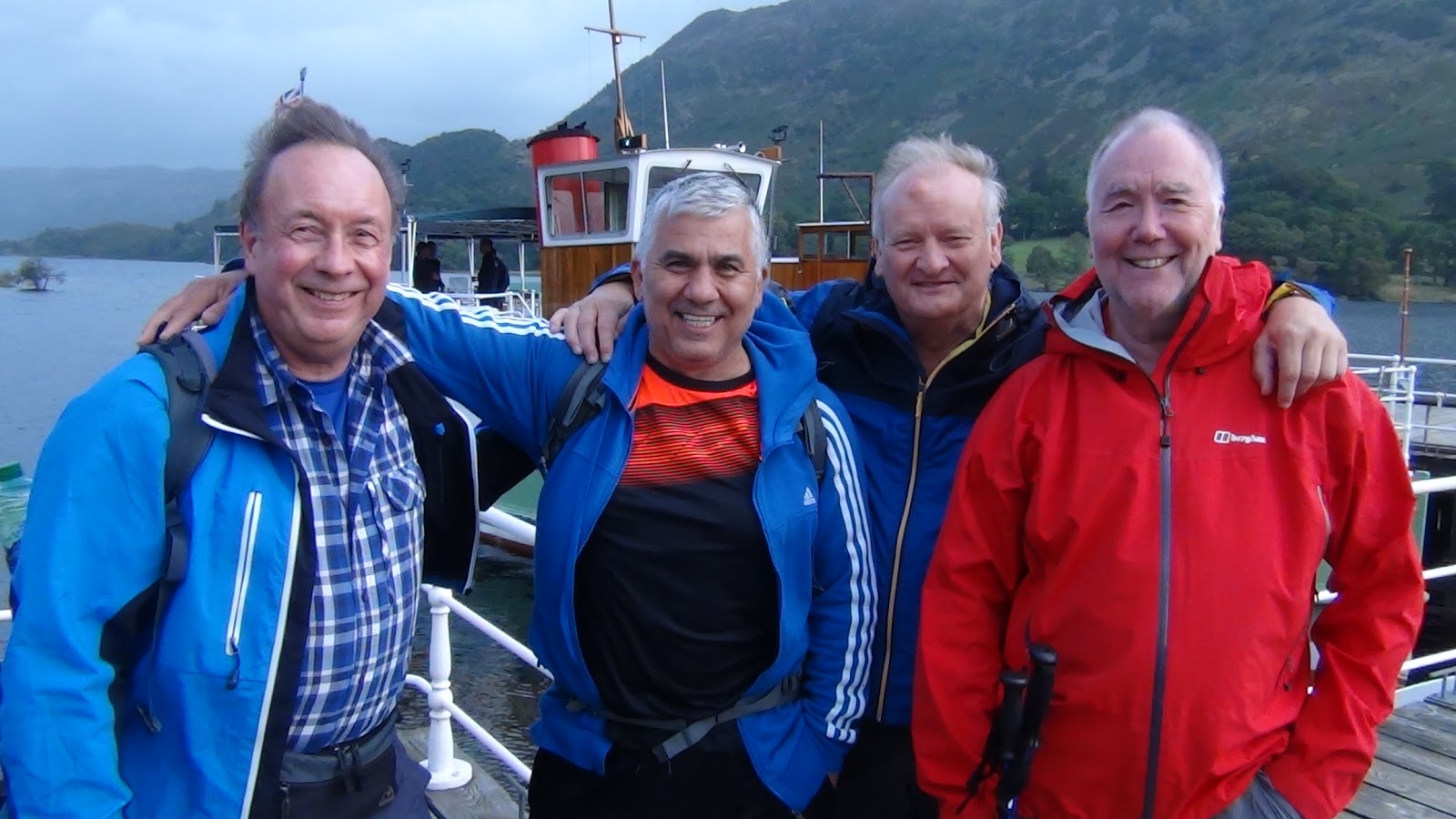 |
| The men from Manchester. |
Other
hikers must have figured out this alternative way as well for there were many
waiting to board the boat when we arrived. We were pleased to see the four men
from Manchester were there getting ready to board while having fun and joking
around just like they did when we first met them yesterday while on the trail.
What a fun bunch of guys.
The map I bought back at the shop on Patterdale, marked up for us by the kind and very helpful proprietress, showed us the way across the open lands along and then away from the lake. Various paths crisscrossed the area making for some confusion.
Once underway we came across another couple, walking about on a day hike, who seemed turned around and asked if we had better information than what they had on their simple map. There was no way they would have found their way without using the information from our more detailed map that we happily shared with them.
These
open lands afforded views of the mountain tops and highlands back along the
original, more treacherous route. The peaks were shrouded in deep, menacing
clouds. It had to be just terrible up there. In fact, we would later learn from
two hikers who had staggered into our hotel that they took this higher route.
They were constantly in the rain, got thoroughly soaked, and battled winds so
strong they nearly got knocked over a time or two.
 |
| Dark and foreboding best describes the route high up in the mountains, a route we fortunately did not take. |

Meanwhile,
we enjoyed a mix of sun, a pleasant sun shower or two, and a sprinkle here and
there along our alternative route. On more than one occasion were we treated
with a spectacular rainbow over the land before us.
 |
| We saw rainbows on numerous occasions. |

After
ten miles, the beauty before us became invisible as our focus turned to how tired and fatigued we were getting. The path became more of a dark depression
in the grass across the pastures instead of the more typical gravel or dirt
trail.


 |
| The path became nothing more than a faint track across pasture land. |

 |
| We had no idea what kind of animal this was - something of a cross between a sheep and a pig. |
Eventually,
we reached the outskirts of Shap where we found the ruins of an ancient abbey.
After poking around a bit, we dragged ourselves into town buoyed by the promise
of a hot shower, a belly full of food, and the knowledge that we have just
finished walking the first third of our 200 mile trek across northern England.


For Part Three of our journey, please go here.
A music video of our 200 mile hike can be seen at the end of the Part Three post.
Comments
Post a Comment