
The baggage carousel went round and round, only producing
MK’s bag and the bags of other passengers who, like us, had a very short connection
through Dublin on our way to Paris. My bag? It was nowhere to be seen. A record
was made at the baggage services area with no promises given as to when I might see it
again.
Then, on the late afternoon train from Charles de Gaulle airport to our hotel in downtown Paris, I accidently kicked Mk’s broken toe with my boot when the train lurched from side to side. She had broken it back home five days before our departure putting into jeopardy our enjoyment of this trip, which has been planned with a lot of walking, hiking, and biking throughout France. To add to her misery, a fellow passenger, hurriedly making for the exit at one of the interim stops, dragged his very large and heavy roller suitcase right over her foot.
And all of this was under the cloud of COVID, with the complicated rules, procedures and precautions that the French government had put in place. One such rule is to have in your possession a “health pass”, which shows you have been vaccinated and/or have had a negative test in the past 72 hours. Such a pass allows you entry into restaurants, museums, and other large gathering places as well giving you access to cross-country train rides. Since we plan on doing all of these and more, I sweated over how I would fare. I applied for these on-line prior to our trip. Only MK received hers. We left for France with me being without on the vague hope that my US CDC card would suffice.
It was with this most inauspicious start that we began our one month in France. Our first two weeks would be spent in Chamonix followed by one week touring various chateaux in the Loire Valley (see trip report here). Our final week would be spent in Paris (see trip report here) visiting the sites we didn’t have time to when we were last there three years agon
Fortunately, while walking around the area of our hotel, we entered a pharmacy that I had heard about from an internet source when back at home. For a generous tip, they would gladly convert my CDC card into the very valuable “health pass”. Relief? You betcha! I can’t tell you how good it felt to get this document and to no longer have the stress of fretting about it.
 |
| Cover page of my most-coveted and very valuable French "Health Pass". |
Despite MK’s injury, we were confident and content the next
morning as we made our way on the long-distance train to the village of
Chamonix in the French Alps. Our plan is to take a variety of day hikes up in
the mountains and down in the valleys. What follows are the description of
these hikes along with accompanying photos.
 |
| The view from our Chamonix apartment balcony. |

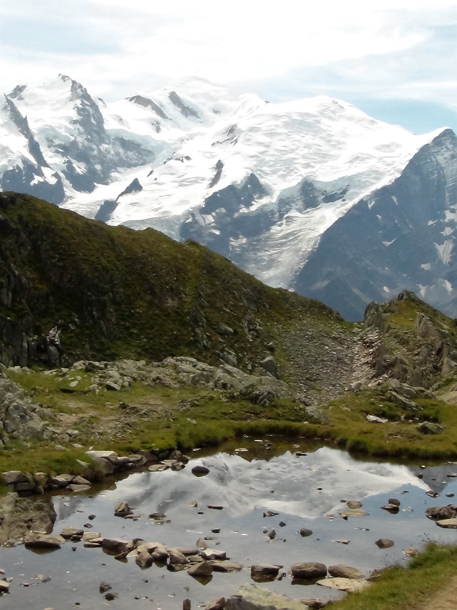
We arrived to the nearby village of Le Tour taking one of the frequent shuttle buses that were free to use by those who stay in the Chamonix Valley. This village served as the terminus of a two-cable car combo that took us up to Col de Balme. It was there that we began our day’s alpine hike on a portion of a route we skipped last time we were here 14 years ago when we circumnavigated Mont Blanc as a part of the 100-mile Tour du Mont Blanc long distance hiking route.
The beginning of the trail straddled the French/Swiss border for a stretch. Views of the snowy peaks of Mont Blanc and its neighboring mountains along with the numerous granite walls, brilliant snow fields, and rugged glaciers that descended from them were vast and imposing. It was if we were staring at a painting that we could reach out and touch only to be dispelled of such an illusion when we realized that what we saw before us was indeed real.


Before heading up to the next ridge, we first had to take a slow descent into a mountain meadow dotted with very large cows. Every single beast was busy grazing and seemingly unbothered by the large metal cowbells under their necks. Their clanging and ringing could be heard from very long distances.

We ascended to Aiguillette des Posettes where we lunched on French sausage and cheese sandwiches while gazing at even more views of the imposing glaciers and mountain peaks that were now dotted with puffy cumulus clouds that were closing in as morning turned to afternoon.


Aiguille du Midi (nominal)
The most impressive of the cable cars in all of Chamonix is the one that takes you up from the valley floor to the 12,600-foot Aiguille du Midi, a spire of a mountain peak with commanding mountain and glacier views. With no time to acclimatize, you very quickly feel the effects of altitude when reaching the top after the cable car’s speedy 20-minute ascent.
 |
| The cable car takes you all the way to the tippy-top. |

You soon forget about your light-headiness when at the top, you see the range of mountains and Mont Blanc right before your eyes as well as the now tiny village of Chamonix far below.


Very brave mountain climbers and snow field trekkers, some of who accompanied us on the cable car ride to the top, quickly made their way out and onto the dangerous snow and ice fields to enjoy their sport. Not for us, that is for sure. We preferred the relative safety of the man-made platforms and decks that were made for the more faint-hearted among us.


We enjoyed a beverage of cold beer and sparkling water at
the cable car’s mid-point before the afternoon clouds began to build. We got
down back to town just as the skies open up from that day’s thunderstorms.


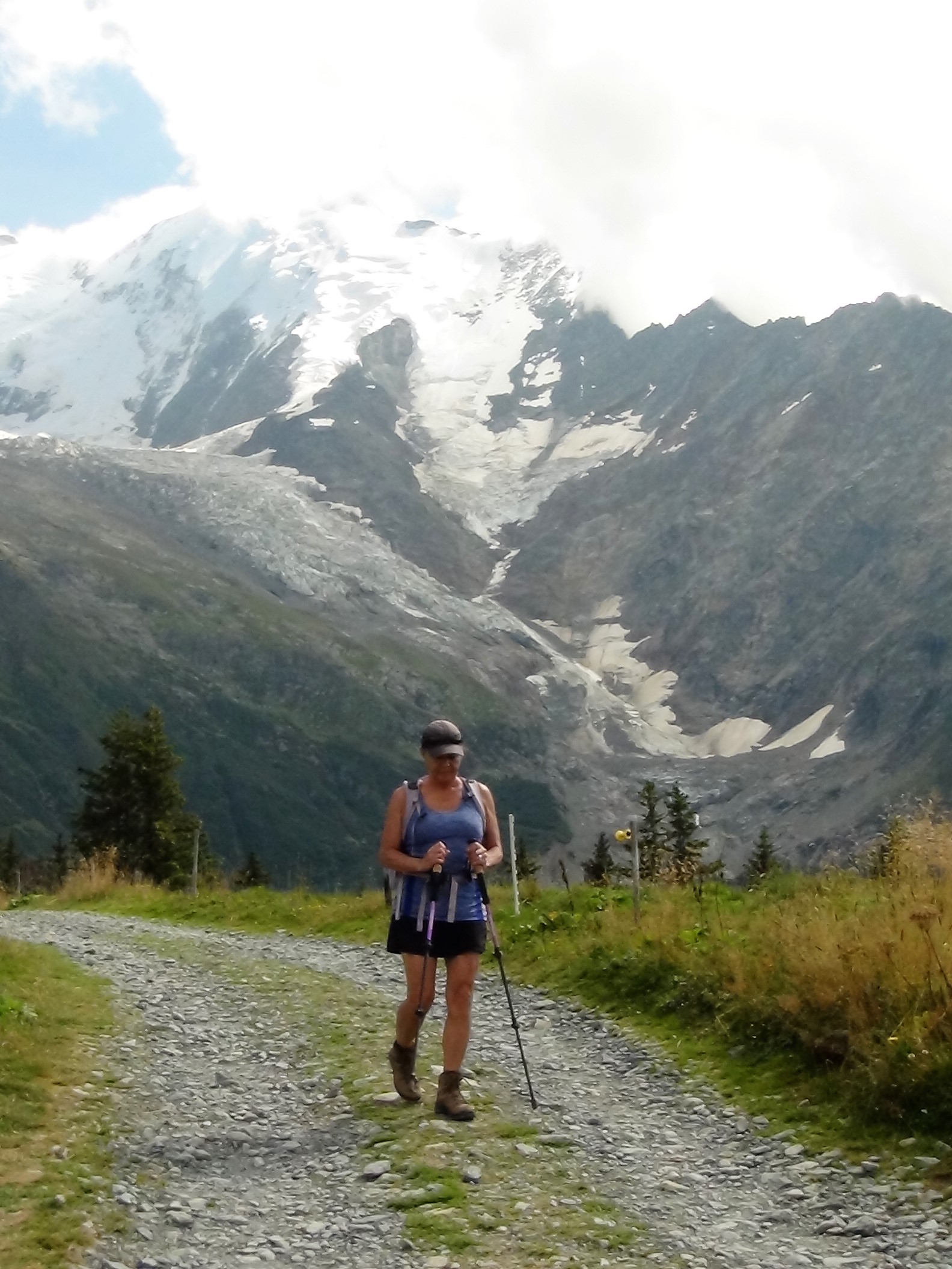
Les Bossons Glacier (6.5 miles)
MK rested her toe while I took off on a solo hike to the foot of the Bossons Glacier. The stiff climb up a series of switch-backs followed the moraine that was formed between Bossons and the nearby Taconnaz glacier that is its neighbor.
 |
| Bossons Glacier. |
 |
| Taconnaz Glacier. |
On display near a chalet half-way up the trail are relics and remnants of an Air India airplane which crashed into the nearby mountainside in 1966 killing all 117 on board (interestingly, in the same area sixteen years earlier, another Air India plane crashed killing all 48 on board that flight). Many of these remnants continue to be uncovered by the receding glacier. Most notable was a metal box found by an alpinist in 2013. In it were gemstones valued at $300,000, which after considerable research, were returned to the family members of the then rightful owner.


I ascended further up the trail to yet another chalet for a refreshment break. This chalet’s placement puts you right up and next to the brilliant white crevasse’s and seracs of the glacier. Waterfalls from its melting face were numerous. Mont Blanc and paragliders served as a back drop far above.


The glacier continued to crack and groan while I lingered. At one point, a large boom preceded a cascade of ice and rock from a building sized chunk that calved off of one of its leading faces.

Before descending, I had to toast Mother Nature for sharing with me this experience of her force and power.

And, great news! Upon arrival at our apartment, and after five long days, my lost luggage was found and delivered to me! Thank goodness. While I did a lot of hand washing in the bathroom sink with what little clothing I had with me in my carry-on, things were getting a little ripe. Calls for yet another toast, don't you think?
Chamonix Valley walks (varying distances)
There were days with unsettled weather. There were also days where we were not feeliing ambitious enough to hike high up in the mountains. When these occured, we took advantage of the several routes in the villages throughout the valley. The distances walked ranged from five to eight miles. It was nice to leisurely walk along the the various trails, stopping here and there for refreshments, and to soak in the culture of this corner of France.
 |
| Waiting for the bus to take us to our next village and its walking trails. |


Brevent Loops (7.5 miles)
MK joined me for the ride up the various cable cars to take in the spectacular views, but did not walk on the trails with me due to the lingering pain in her broken toe. It was interesting to view the glaciers that I was up next to the other day, but now from the distance caused by the valley that separated us.


This was also a spot for paragliding enthusiasts to launch their flights. Dozens of people patiently waited their turn to fill their parachutes with the wind coming up-valley, take a fast running start, then a leap off of the cliff for what looked like hours of enjoyment riding thermals far above.


I spent a good portion of the afternoon enjoying the heights while soloing along the ridge line. After having a refreshing beverage at a remote refuge that was precipitously perched on the edge of a cliff, I began my steep switch-backed descent.
 |
| Many rock climbers enjoyed this area as well. |


After an hour or so into my descent, my boot caught the edge of one of the innumerable rocks in just the right way that it sent me sprawling on the trail ahead of me. My reliable trekking poles usually serve to arrest such trips and falls. But not this time. My forward, downhill motion was simply too much for my withering strength and the poles to overcome. My right ear took the brunt of the impact when I turned my face at the last second just before my head hit one of many trail-side rocks.
As I began to try to staunch the flow of blood, I was puzzled as to why I couldn’t raise my now numb left arm. It took me a while to realize that my shoulder was dislocated. To avoid lingering injury (and the need to continue the use of my arm during the rest of the descent), I worked the shoulder in such a manner as to painfully pop the joint back into place. It was only then that I was able to continue my attention on my injured and bloody ear. In time, I dusted myself off and proceeded with the rest of my descent. I was certainly hobbled, but was able to continue none the same.
While an unfortunate occurrence, this fall could have been so much worse. Instead of falling forward, I could have gone off to my left side and a certain fall of ten to fifteen feet to the next switchback below. And, in falling forward, I could have hit my head on one of the many jagged and sharp rocks that littered the trail instead of the lone unusually flat-surfaced rock with whom I made my acquaintance.
MK’s horrified look when she first saw me when I walked back into our apartment was memorable. But she quickly turned into compassionate nurse mode as she attended to my wounds. While patching me up, she mentioned how lucky I was to have turned my head at the last second so that my ear, instead of my face, had hit the rock. I couldn't agree more. It would have been messy indeed. Any remaining chances at late career modeling jobs or glamorous photo shoots would have otherwise disappeared forever!
 |
| Steri-strips and band-aids to the rescue! |
Lacs Noir (4.5 miles)
I was surprised at how well I felt the next morning. A little sore, for sure. A bit disfigured as well. But, I was up and out for the next day's hike full of energy.
One of the two cable cars up to the trailhead was of the open-air variety. When I approached the platform, the operator and a young lady began to question me in French. The young lady quickly recognized that I was not at all understanding what they were asking and converted her questioning into English. She had never ridden in an open-air chair lift and was terrified to do so alone. She asked me if she could she join me for the ride up showing her how it worked. I gladly obliged and we were on our way.

My route up to the high alpine lakes was rough and precipitous. I made my way upwards along the narrow tread of the trail that clung to the edge of the bowl-shaped cirque surrounded by the towering heights of its adjoining mountains.


When the trail narrowed even further, forward progress could only be had through the use of the via ferrata (iron rungs, chains, ladders, etc.) that were strategically placed into the face of the cliff. But for their placement, certain injury, or maybe even death, would result from what would otherwise be a very likely fall down into the valley.


At the col, the trail turned northward with a continued ascent up to the lakes and across several snowfields. Every time I reached what I thought would be the top where I would be able to gaze upon the lakes, I would instead see yet another larger hill to climb. These false summits, one after another, continued for the next 20 minutes or so until finally I was able to stop and linger around these gems of water high up in the mountains.


I was hesitant to descend and return to the trailhead. I would have to again negotiate the via ferrata which was not one of my favorite things to do. Of course, halfway across this, a women hiker came from the opposite direction. "I hate this part," she said in her German accented English as we approached eachother. Somehow we managed the passage despite having very little room to do so.
 |
| The dreaded via ferrata (left side of the picture). |
After fifteen minutes or so, the sound of footsteps approached
from behind. A young lady, perhaps in her mid-twenties with flaming red-dyed hair, was running down the trail and soon overcame me. She was lighter than
air, skipping from rock to rock, gaining ten feet of descent for every one foot
of my plodding. I kept up my slow pace, looking as the distance between us grew
larger by the minute, knowing I would be in traction if I tried to keep
up. I eventually made my way back to the cable car platform for a refreshing and enjoyable ride back down to the valley.  |
| Mer de Glace glacier on the other side of the valley was visible from my cable car. |

Mer de Glace (3.5 miles)
This highly touted route from halfway up Aigulle du Midi northeasterly to Montenvers and the Mer de Glace did not live up to the expectations. Of all the trails we have hiked in Chamonix, this may have been our least favorite.
Now, all things are relative, right? Place this trail anywhere else in the world, and it would be considered world class. The trouble with it is that it is amongst many other world class trails here in the valley. So, if one has to rank, this is ranked near the bottom.


But, let’s talk about the good parts. First, is that you take a cable car up the slopes to avoid what would otherwise be a grueling ascent. Then, this three-mile trail generally follows the 2100-meter contour, so there isn’t much up and down to have to negotiate. Then, once finished, you have the option of taking a cog-wheel train back down to the valley. As one of our trail guide books says: “A relatively flat trip bookended by rides on a cable car and a train. What decadence!”
The true payoff is not the trail itself but instead when you reach its end. When your turn one last corner, you are presented with a fabulous view of the Mer de Glace glacier, one of the longest in this part of the Alps Mountain range.


After taking one too many pictures of this “sea of ice”, you then take another gondola down to the beginning of a 500 plus step stairway that takes you even further down to the entrance into the ice caves that are bored into the side of the glacier. The steps are designed somewhat like an erector set, being easily dismantled and re-set as the glacier moves. It was alarming to see markers along the stairway that described how much the glacier has retreated just in the past twenty years or so.


Back to the top, and it was time for a brief tour of the historic Montenvers Hotel, some small museums about geology and glaciology, and one last look at the Mer de Glace. Boarding time was announced and we were on our way back down to the valley via the cog wheel train.


Col de Voza (5.5 miles)
An inebriated man joined us at the bus stop bench waiting for our ride to the village of Les Houches where we plan on ascending to the high country via one of two cable cars located there. Even though he sat on the far end of the bench, the odor of stale alcohol from his breath and clothing was overpowering.
After we arrived in Les Houches at the base of the cable car, we noticed a dozen or so disabled tourists gathered around the platform while their specially designed non-motorized four-wheel mountain carts were loaded into the cable cars. While these tourists would be ascending later, able-bodied hikers were being asked to accompanying their carts for their ride to the top of the col. We gladly obliged and squeezed in the cable car with one of these adaptive vehicles and assisted the workers at the top in getting it out of the car before it began its next descent. We would later see these folks joyfully riding their carts along the mountain trails assisted by their guides.
Our trail traversed the mountain meadowlands. Grazing cows, sheep, and horses were prevalent. In fact, at one fenced in area, there was a man feeding and watering several horses. It was the drunk guy we saw back in town at the bus stop! Apparently, after (or during) an all-out bender, he had the presence of mind to remember he had a job to do high up in the mountains this morning.


A mountain tram was running along our route even though the visitor center’s widely distributed brochures said it had stopped operating for the season last week. It is a shame really for I had a hiking route planned with the use of this tram, yet abandoned the idea when I learned it wouldn’t be running. And given the revised itinerary I had since created, it no longer made sense to pay the money to ride this tram. So, I took pictures of it instead.


This wasn’t the first time something didn’t square up with the information given at the tourist information center back in town. The desk staff there had been less than helpful.
While we had questions, and they gladly answered them, they
didn’t volunteer any additional information beyond the questions we asked.
Would it be asking too much for them to say: “Hey, we know the brochure says this, but here is the real situation out there on the trails.”
The trail we planned on taking would have delivered us to a
suspension bridge over the main outlet of the melting Bionnassay Glacier. But,
after a stretch, it narrowed into a precipitous tread where the way forward was
only possible through the use of the via ferrata bolted into the cliff-side.
One fall here and we’d still be rolling downhill by the time you read this. The
drops next to the trail where these were located were significant. So, because
of our feebleness and, more likely fear, we decided not to proceed further and
instead headed back to the La Chalette buvette (snack bar) we saw earlier.

It ended up being a good choice for we later learned from
others that we didn’t miss anything for the bridge was closed due to flooding
earlier in the year, information the people at the tourist information center hadn't thought to share with us. Hello Tourist Info Center. Anyone home? Hello? Bueller?
Bueller?!
Before returning to the cable cars, we relaxed at the snack shop with our beverages while viewing the scenery and watching other hikers come and go. It was most serene.


Except for the dogs. Dogs and more dogs being led by the human hikers filed through. Now, we have nothing against dogs but come on! One dog in particular would go berserk and bark at any other passing furry friend filling the mountainside with noise and a most intrusive cacophony. He was definitely harshing our mellow.
Lac Blanc (3.5 miles)
The haze and lingering clouds of the early morning finally gave way as we ascended up the Flegere and Index cable cars to the start of our day’s hike. The very popular 1.75-mile trail to Lac Blanc, buzzing with fellow hikers at our early 9am hour, was to be our last hike while in Chamonix. As it turns out, it ended up being one of our favorites during the whole of the two week stay. The views from across the valley of the glaciers and snow-capped peaks, starring Mont Blanc itself, were tremendous.


As we walked, we commented on how different mountain hiking here in Europe is compared to hiking back in the U.S. Here, cable cars are ubiquitous, allowing one to avoid the grueling climb up from the valley far below. In almost an instant, you are up above tree-line enjoying the alpine meadows and mountain peaks. This ease of access also means more hiker amenities such as chalets, refuges, restaurants, and snack bars. It all lends itself to a most enjoyable, more personal, and civilized way to hike and enjoy for fresh mountain air.
In the U.S., distances are vast. Trails are long. The mountains aren’t up close and personal the way the “in your face” mountains are in Europe. In the U.S., it takes all day, sometimes multiple days, to get to the similar high mountain environment. Even then, the mountains are oftentimes still far away. And it takes a lot of effort to get there as well. The trade-off for the likely wilderness designations of these vast areas in the U.S. is the relative lack of hiker amenities. If you want something (refreshments, snacks, etc.) then you better have brought it with you strapped to your back or you will go without.
We eventually reached the end of the trail where a well-situated refuge and restaurant overlooks everything. Most notable are the lakes themselves with their milky blue-ish green hue caused by the glacial melt from far above.


We descended by the same cable cars that took us up here this morning. Halfway down, at the cable car switch over station, we had a decision to make. The choices, though, were simple.
One: continue on down on the next cable car, catch the bus, and make it back to the hub bub of town and our waiting apartment. Or two: sit ourselves down in some comfy chairs overlooking the snowy mountain range, bask in the warmth of the late afternoon sun, and contemplate everything about our great day’s hike with a cup of thick coffee and a refreshing draft beer.
I think we all know what choice we made.


Comments
Post a Comment